
Datei:Sámova říše.png

Originaldatei zum Herunterladen (852 × 850 Pixel, Dateigröße: 184 KB, MIME-Typ: image/png)
Dieses Medium wird direkt von Wikimedia Commons aus eingebunden. Quellenangaben und Lizenzbedingungen befinden sich auf der unten zusätzlich eingeblendeten Commons-Beschreibungsseite.

|
Dieses Bild des Typs Map sollte als Vektorgrafik im SVG-Format neu erstellt werden. Vektorformate haben zahlreiche Vorteile; weitere Information unter Commons:Media for cleanup. Wenn dir eine SVG-Version dieses Bildes vorliegt, so lade diese bitte hoch. Nach dem Hochladen der Datei ist diese Vorlage auf der aktuellen Bildbeschreibungsseite durch die Vorlage {{Vector version available}}, oder kürzer {{Vva}}, zu ersetzen. Es ist empfohlen die neue SVG-Datei „Sámova říše.svg“ zu nennen – dann benötigt die Vorlage vector version available (bzw. vva) keinen Parameter.
|
| Beschreibung |
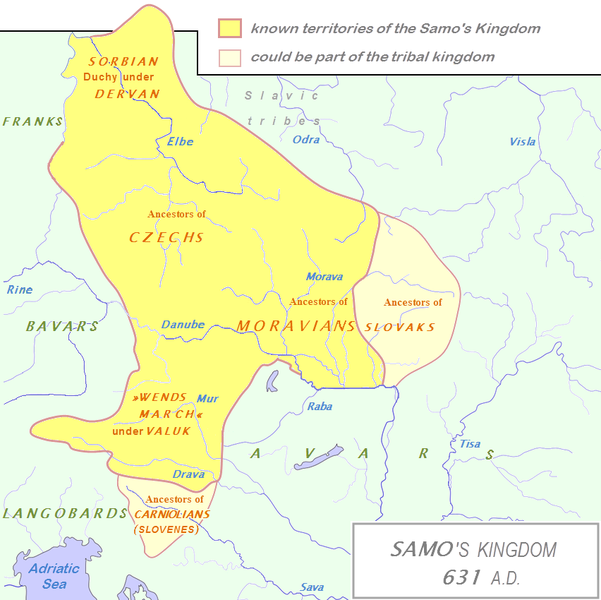
English: Tribal Kingdom of Samo.
Map is based on the maps in:
It is also based on descriptions in:
For eastern and southern extant of tribal kingdom: known territories are shown by the scheme of franco-slavic border and information about the conflicts with Avars is imlemented. The inclusion of Bohemian basin is followed. Contacts with Avars are reached through the territory of Moravians and Eastern Alps. The territories further east and south, which are in proximity of Avars, could be parts of tribal kingdom, too. |
| Datum | (UTC) |
| Quelle | |
| Urheber |
|
| Dieses Bild wurde digital nachbearbeitet. Folgende Änderungen wurden vorgenommen: The map of Danube basin was used to create map of Kingdom of Samo. Das Originalbild kann hier eingesehen werden: Tribal Kingdom of Samo-sl version.PNG:
|
| Ich, der Urheberrechtsinhaber dieses Werkes, veröffentliche es als gemeinfrei. Dies gilt weltweit. In manchen Staaten könnte dies rechtlich nicht möglich sein. Sofern dies der Fall ist: Ich gewähre jedem das bedingungslose Recht, dieses Werk für jedweden Zweck zu nutzen, es sei denn, Bedingungen sind gesetzlich erforderlich. |
Ursprüngliches Datei-Logbuch
This image is a derivative work of the following images:
- File:Waterways_of_SE_Central_Europe.svg licensed with PD-self
- 2010-01-08T20:49:27Z Kmiki87 1415x1059 (292577 Bytes) {{Information |Description={{en|1=Waterways along the central and lower Danube, including the Bohemian and Carpathian Basins, the northern Balkans, parts of Austria, southern Poland and Western Ukraine.}} |Source={{own}} |Aut
Dateiversionen
Klicke auf einen Zeitpunkt, um diese Version zu laden.
| Version vom | Vorschaubild | Maße | Benutzer | Kommentar | |
|---|---|---|---|---|---|
| aktuell | 16:27, 3. Jan. 2013 | | 852 × 850 (184 KB) | DancingPhilosopher | Better map based on http://commons.wikimedia.org/wiki/File:Tribal_Kingdom_of_Samo-sl_version.PNG |
| 16:13, 28. Okt. 2010 |  | 536 × 474 (616 KB) | Aktron | == {{int:filedesc}} == {{OpenStreetMap|name=Sámova říše}} Category:Maps of the history of Austria Category:Maps of the history of Slovakia Category:Maps of the history of Slovenia [[Category:Maps of the history of the Czech Republic |
Dateiverwendung
Die folgende Seite verwendet diese Datei:
Globale Dateiverwendung
Die nachfolgenden anderen Wikis verwenden diese Datei:
- Verwendung auf ar.wikipedia.org
- Verwendung auf azb.wikipedia.org
- Verwendung auf az.wikipedia.org
- Verwendung auf be.wikipedia.org
- Verwendung auf bg.wikipedia.org
- Verwendung auf ca.wikipedia.org
- Verwendung auf cs.wikipedia.org
- Verwendung auf de.wikipedia.org
- Verwendung auf en.wikipedia.org
- Verwendung auf et.wikipedia.org
- Verwendung auf fa.wikipedia.org
- Verwendung auf fr.wikipedia.org
- Verwendung auf hy.wikipedia.org
- Verwendung auf id.wikipedia.org
- Verwendung auf it.wikipedia.org
Weitere globale Verwendungen dieser Datei anschauen.