
Datei:Geomap Rhoen.jpg
Größe dieser Vorschau: 576 × 599 Pixel. Weitere Auflösungen: 231 × 240 Pixel | 461 × 480 Pixel | 738 × 768 Pixel | 984 × 1.024 Pixel | 1.969 × 2.048 Pixel | 3.549 × 3.692 Pixel.
Originaldatei zum Herunterladen (3.549 × 3.692 Pixel, Dateigröße: 2,69 MB, MIME-Typ: image/jpeg)
Dieses Medium wird direkt von Wikimedia Commons aus eingebunden. Quellenangaben und Lizenzbedingungen befinden sich auf der unten zusätzlich eingeblendeten Commons-Beschreibungsseite.
Beschreibung
| Beschreibung |
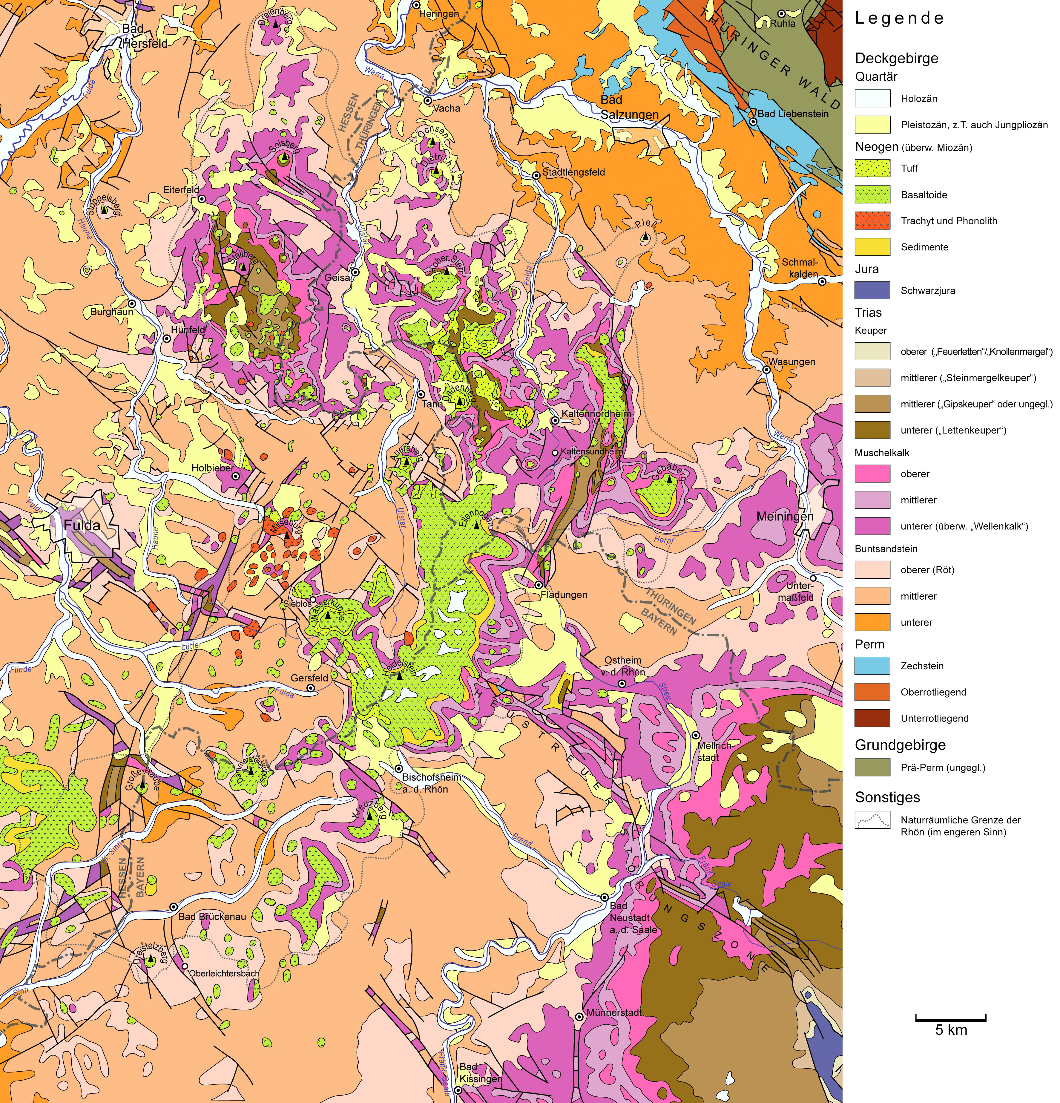
English: Geological map of the Rhoen Mountains, a volcanic mountain range in Central Germany. Data source: official geological maps of Hesse, Thuringia, and Bavaria.
Deutsch: Geologische Karte der Rhön. Quellen: GÜK 300 Hessen, GÜK 200 Thüringen, GÜK 500 Bayern. |
||
| Datum | |||
| Quelle | Eigenes Werk | ||
| Urheber | Gretarsson | ||
| Andere Versionen |
|


Lizenz
Ich, der Urheberrechtsinhaber dieses Werkes, veröffentliche es hiermit unter der folgenden Lizenz:

|
Es ist erlaubt, die Datei unter den Bedingungen der GNU-Lizenz für freie Dokumentation, Version 1.2 oder einer späteren Version, veröffentlicht von der Free Software Foundation, zu kopieren, zu verbreiten und/oder zu modifizieren; es gibt keine unveränderlichen Abschnitte, keinen vorderen und keinen hinteren Umschlagtext.
Der vollständige Text der Lizenz ist im Kapitel GNU-Lizenz für freie Dokumentation verfügbar. |
Diese Datei ist unter den Creative-Commons-Lizenzen „Namensnennung – Weitergabe unter gleichen Bedingungen 3.0 nicht portiert“, „2.5 generisch“, „2.0 generisch“ und „1.0 generisch“ lizenziert.
- Dieses Werk darf von dir
- verbreitet werden – vervielfältigt, verbreitet und öffentlich zugänglich gemacht werden
- neu zusammengestellt werden – abgewandelt und bearbeitet werden
- Zu den folgenden Bedingungen:
- Namensnennung – Du musst angemessene Urheber- und Rechteangaben machen, einen Link zur Lizenz beifügen und angeben, ob Änderungen vorgenommen wurden. Diese Angaben dürfen in jeder angemessenen Art und Weise gemacht werden, allerdings nicht so, dass der Eindruck entsteht, der Lizenzgeber unterstütze gerade dich oder deine Nutzung besonders.
- Weitergabe unter gleichen Bedingungen – Wenn du das Material wiedermischst, transformierst oder darauf aufbaust, musst du deine Beiträge unter der gleichen oder einer kompatiblen Lizenz wie das Original verbreiten.
Du darfst es unter einer der obigen Lizenzen deiner Wahl verwenden.
Dateiversionen
Klicke auf einen Zeitpunkt, um diese Version zu laden.
| Version vom | Vorschaubild | Maße | Benutzer | Kommentar | |
|---|---|---|---|---|---|
| aktuell | 22:35, 24. Mär. 2021 | | 3.549 × 3.692 (2,69 MB) | Gretarsson | last version was accidentally saved in CMYK color space causing rendering errors |
| 21:43, 24. Mär. 2021 |  | 3.549 × 3.692 (4,35 MB) | Gretarsson | missing town label “Bad Liebenstein” added; label “Basalt” in legend replaced by “Basaltoid” since this is more accurate (SiO2-poor volcanic rocks in Rhön Mts are not only basalts in a stric sense but includes also basanite and nephelinite) | |
| 16:56, 14. Jun. 2013 |  | 3.549 × 3.692 (4,53 MB) | Gretarsson | Border of physical geographic unit "Rhoen Mts. sensu stricto" altered + some minor edits (e.g. typos) | |
| 16:56, 13. Jun. 2013 |  | 3.549 × 3.692 (4,53 MB) | Gretarsson | Map extended northward and eastward. Missing features in old map (1 town, a few faults) added. | |
| 12:32, 29. Mai 2013 |  | 3.194 × 3.437 (2,54 MB) | Gretarsson | {{Information |Description ={{en|1=Geological map of the Rhoen Mountains, a volcanic mountain range in Central Germany. Data source: official geological maps of Hesse, Thuringia, and Bavaria.}} {{de|1=Geologische Karte der Rhön. Quellen: GÜK 300 H... |
Dateiverwendung
Keine Seiten verwenden diese Datei.
Globale Dateiverwendung
Die nachfolgenden anderen Wikis verwenden diese Datei:
- Verwendung auf de.wikipedia.org
- Verwendung auf en.wikipedia.org